A high-value forest requires a different research approach.
Rainforest research requires continuous observation, spatial distribution and longitudinal context. More observation should not automatically mean more physical presence.
Continuous Observation
Extend scientific visibility between field visits instead of replacing field researchers.
Distributed Measurement
Move from isolated measurements toward spatially meaningful research coverage.
Minimum Necessary Presence
Deploy only where scientific value justifies ecological presence.
Continuous visibility between field visits.
Field expeditions, fixed stations, satellites and periodic drone surveys remain essential. IDRCIN fills the gap: continuous, distributed, relocatable and low-presence monitoring.
Field Expedition
Strong judgement and sampling, but episodic and presence-intensive.
Fixed Station
Continuous at one location, but spatially inflexible and persistent.
Remote Survey
Large-area context, but not continuous local measurement.
IDRCIN
Distributed continuous measurements with a temporary, relocatable field layer.
A moving scientific grid.
The sensing layer can be retrieved, inspected, calibrated and redeployed as research questions evolve.
Map first. Route second. Deploy third.
Reconnaissance, Digital Twin, ecological routing, drone deployment, lightweight sensing, Zonal DAQ, Main Intelligent DAQ and TM Cloud work as one layered research infrastructure.
Extremely lightweight at the research point.
The spool stores fibre, manages controlled payout and houses the built-in quick release. Mechanical load is carried by a dedicated support tether not by the fibre optic line.
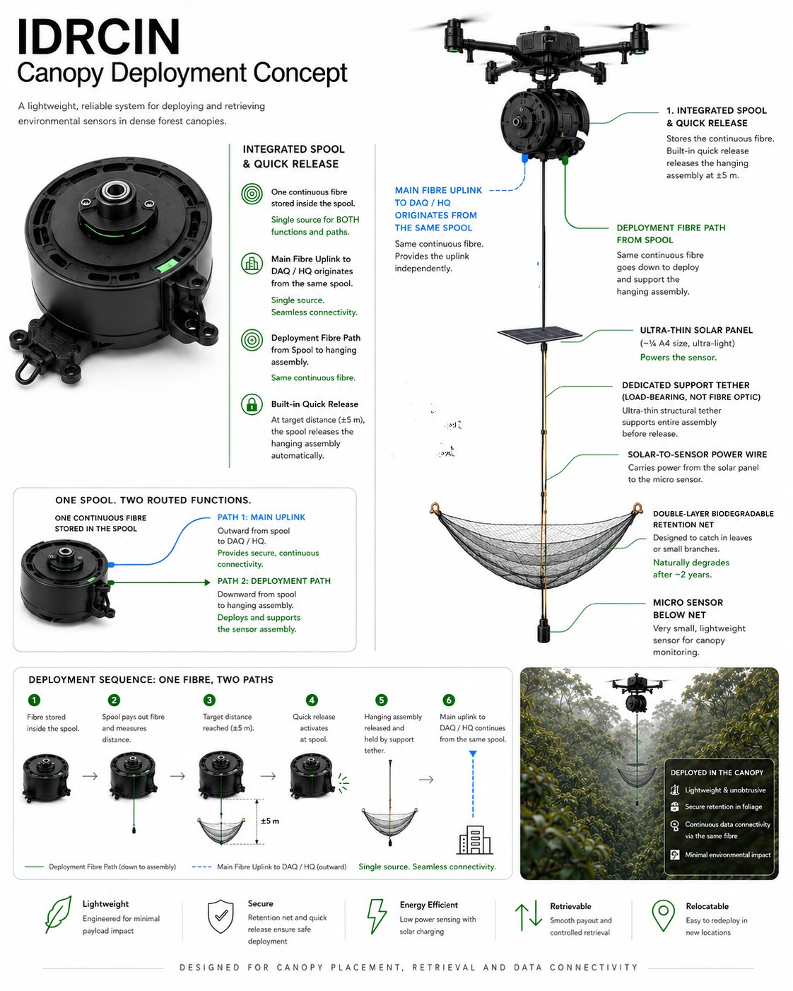
One Spool Two Routed Functions
Main uplink to DAQ/HQ and the deployment fibre path both originate from the integrated spool.
Dedicated Support Tether
The tether carries mechanical load. Fibre remains a communications medium.
Solar → Net → Sensor
Ultra-thin solar panel above, retention net in the middle and micro sensor below, with a separate power wire.
One Point One Sensor.
Redundancy is spatial, not duplicated inside each research point.
Reliability is budgeted from day one.
Phase 2 includes a complete replacement reserve rather than assuming tropical field hardware will never fail.
Operational redundancy where it matters.
One reconnaissance platform plus two deployment/retrieval-capable aircraft.
LiDAR, RGB, Digital Twin, route verification and inspection.
Spool deployment, sensor placement, fibre operations and retrieval.
Operational redundancy and retrieval resilience.
Keep sensors simple. Move intelligence inward.
48 sensors → approximately 4 Zonal DAQs → Main Intelligent DAQ → TM Cloud / HQ.
Zonal DAQ
Acquisition, IoT, local storage, health monitoring, validation and NeuralOps.
Main Intelligent DAQ
Aggregation, cross-zone validation, field storage and sync management.
TM Cloud / HQ
Long-term storage, Digital Twin, dashboards, APIs and analytics.
No monitoring system has zero impact.
IDRCIN is designed for low routine human presence, temporary technology presence, high data continuity and high spatial flexibility.
No Physical Monitoring
Very low presence, low continuous local data.
Conventional Field Monitoring
High scientific value, repeated access may be required.
Permanent Infrastructure
Strong continuity with persistent footprint.
IDRCIN
Temporary, relocatable research layer.
Less presence, less carbon.
IDRCIN budgets energy and carbon rather than assuming them away.
Fewer human trips
Drone-deployed, retrievable sensing reduces repeated access and persistent footprint.
Local-first
Validation on-premise; heavy cloud LLM used sparingly, on demand.
Measured, including TNB
Grid electricity for DAQ/HQ budgeted and disclosed, not assumed.
IDRCIN targets carbon reduction at the physical research layer by reducing repeated field mobilisation. NeuralOps targets carbon reduction at the digital intelligence layer by reducing unnecessary AI processing.
IDRCIN vs Conventional / Manual Monitoring
NeuralOps vs Full-AI Processing
NeuralOps reduces unnecessary AI computation.
From Estimated → Measured
Physical Layer
- vehicle kilometres
- fuel consumption
- drone battery kWh
- number of missions
- human field hours
Digital Layer
- total tokens
- model calls
- server / DAQ electricity
- cloud workload · storage · network
Prove it before scaling it.
The programme is stage-gated. Phase 2 proceeds only after jointly agreed POC acceptance criteria are achieved.
Validate core deployment, communication, retrieval and ecological assumptions.
4 zones, 48 active points, 102 sensor assemblies, 3-aircraft fleet, DAQ, NeuralOps, TM Cloud and full lifecycle validation.
RM2.5M potential programme stage gated.
Not an unconditional RM2.5M commitment. RM500K funds the POC. RM2.0M proceeds only after successful validation.
MODIFY
STOP
Funding creates a complete research capability.
Preliminary planning budget. Final values remain subject to detailed design, site assessment, research requirements and vendor quotations.
Successful Imbak deployment moves directly into steady state.
After the full pilot, Imbak moves directly into an operating steady state with predictable, modest annual planning costs.
Indicative steady-state range: RM0.8M–RM1.2M annually.
Annual OPEX
Operate · Maintain · Calibrate · Retrieve · Redeploy · Cloud / Data · Research Support · Ecology
Expansion is optional not automatic.
A future landscape such as Maliau Basin would be a separate programme with its own mapping, sensor deployment, DAQ infrastructure, ecological baseline and validation.
Science first. Conservation always.
Scientific, ecological and engineering governance connect through joint steering and explicit GO / MODIFY / STOP authority.
Scientific
Research questions, methods, indicators and sampling design.
Ecological
Restricted zones, disturbance limits, presence budget and stop authority.
Engineering
Drone, spool, fibre, DAQ, NeuralOps, cloud and retrieval.