A research infrastructure, not a technology demonstration.
IDRCIN combines reconnaissance drones, LiDAR/RGB mapping, a Temporal Digital Twin, AI-assisted routing, lightweight sensing, zonal DAQ, NeuralOps Detached Systems, TM Cloud, controlled retrieval and rotational redeployment.
Drone-First
Sensor placement, fibre deployment, inspection and retrieval are designed to avoid routine human presence beneath the canopy unless science, ecology or safety requires it.
Dynamic
The sensing layer is temporary and relocatable rather than a fixed permanent grid. Research cycles can move between zones as scientific questions evolve.
Auditable Intelligence
Raw evidence remains preserved while validation, indicators, alerts and projections are versioned, traceable and researcher-governed.
Science must justify every intervention.
Imbak Canyon is positioned here as one of Sabah’s most important pristine rainforest conservation and research landscapes. IDRCIN is designed to strengthen an existing research ecosystem not to turn the forest into a technology showcase.
Research Infrastructure Multiplier
One shared field backbone can support multiple research programmes microclimate, biodiversity, hydrology, atmospheric studies, vegetation, canopy dynamics and other researcher-defined campaigns.
Do-Not-Deploy Principle
If scientific value is low, existing instrumentation is sufficient, remote sensing is adequate, or ecological disturbance is disproportionate, the correct engineering decision is not to deploy.
Not zero impact. Minimum necessary presence.
The proposal compares real alternatives: no physical monitoring, conventional field monitoring, permanent infrastructure and dynamic drone-deployed monitoring.
| Approach | Routine Human Presence | Technology Presence | Continuous Data | Spatial Flexibility | Main Concern |
|---|---|---|---|---|---|
| No Physical Monitoring | Very Low | None | Low | N/A | Information gap |
| Conventional Field Monitoring | Medium–High | Low | Low–Medium | High | Repeated access |
| Permanent Monitoring | Low after installation | Persistent | High | Low | Permanent footprint |
| IDRCIN | Low | Temporary / Relocatable | High | High | Drone, fibre and wildlife interaction |
Ecological Presence Budget
Set limits for sensor count, fibre length, drone missions, hover duration, human entry, maintenance missions and deployment period.
Decision Test
Is the information required? Is this the lowest reasonable intervention? Can the hardware be retrieved? Can impact be measured? Does the benefit justify presence?
Account for presence, energy and carbon honestly.
IDRCIN is positioned against the alternatives it replaces. The table below is indicative and meant to be budgeted against real site data before commitment.
| Dimension | IDRCIN | Manual Field Monitoring |
|---|---|---|
| Routine human presence | Low drone-deployed | High repeated access |
| Data continuity | Continuous, distributed | Episodic |
| Physical footprint | Temporary, relocatable | Persistent stations |
| Carbon from access | Lower fewer human trips | Higher fuel & travel |
| Energy source | Ultra-thin solar + local DAQ | Battery / grid dependent |
Zonal DAQ and Main DAQ run validation and routing on-premise. Only prepared, minimal context is used lower data transfer, lower cloud energy, data stays in the forest network.
Heavy reasoning is optional and on-demand, not a constant background load. This keeps carbon proportional to use rather than idling large models continuously.
Illustrative preliminary estimates, subject to validation. Physical layer: Manual ≈ 1.84 t CO₂e/yr vs IDRCIN ≈ 0.56 t CO₂e/yr (≈70% lower operational field emissions). Digital layer: Full-AI 32B tokens vs NeuralOps 2.5B tokens (≈92% lower variable AI workload; ≈64.5% lower estimated whole-system compute footprint). Figures are scenario estimates not audited lifecycle data and should be replaced with measured vehicle km, fuel, drone kWh, mission count and compute tokens during the POC.
Keep the forest edge light. Move complexity inward.
IDRCIN deliberately separates the dynamic research layer, the intelligent field backbone and the cloud research intelligence layer.
Map first. Route second. Deploy third.
Reconnaissance uses LiDAR/RGB and spatial context before any physical placement. Routing combines physical, ecological and engineering maps. AI proposes; human reviewers approve.
Physical Map
Canopy geometry, terrain, waterways, gaps, obstacles and structural context.
Ecological Map
Sensitive habitat, control plots, nesting areas, conservation restrictions and researcher-defined no-go zones.
Engineering Map
Drone clearance, fibre route feasibility, abrasion risk, retrieval probability and mission safety.
One spool. Two routed functions.
The integrated spool stores the continuous fibre, provides distance-controlled payout, and contains the built-in quick release. The mechanical load is carried by a dedicated support tether not by the fibre optic line.
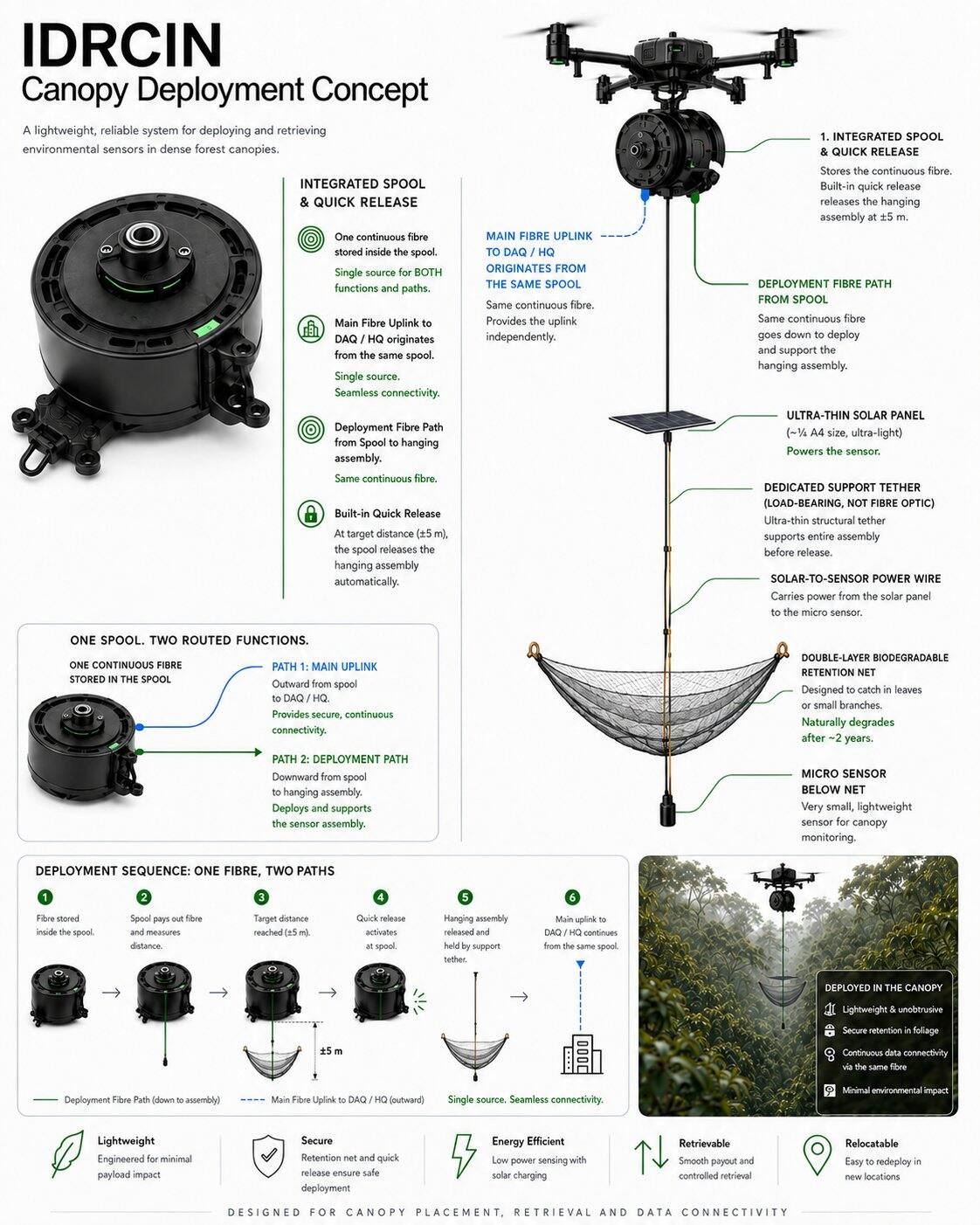
Main Fibre Uplink
The DAQ/HQ uplink originates from the same spool. It is not routed from the sensor, solar panel or retention net.
Hanging Assembly
Ultra-thin solar panel above, double-layer biodegradable retention net in the middle, and micro sensor below the net.
Support & Power
A dedicated load-bearing tether provides mechanical support. A separate solar-to-sensor wire carries power to the micro sensor.
One Point One Sensor.
Every measurement point has a clear spatial identity. Redundancy comes from distribution, not from making each sensor package heavy and complex.
Minimum Edge Complexity
No local database, no unnecessary heavy compute, no oversized battery. If a function can be performed at the Zonal DAQ, keep it away from the canopy sensor.
Research-Defined Sensor Payload
Microclimate, atmospheric/carbon, vegetation, biodiversity, acoustic, hydrology and other measurements are selected by researchers not dictated by the platform.
Researcher-defined intelligence, close to the measurement source.
Each Zonal DAQ combines acquisition, IoT, local storage and a NeuralOps Detached System. Several zones feed a Main Intelligent DAQ for aggregation, cross-zone validation and cloud uplink.
Zonal Intelligence
Real-time validation, missing-data detection, timestamp checks, drift detection, threshold analysis and system-health monitoring.
Main DAQ
Primary field storage, cross-zone context, synchronisation, network management and resilience when cloud links are unavailable.
TM Cloud / HQ
Long-term storage, Temporal Digital Twin, analytics, projection, APIs, collaboration and secure researcher access.
Never let automation overwrite the evidence.
IDRCIN separates scientific evidence from processing outputs and advisory projections.
Four Data Classes
- Raw Data original measurement
- Cleaned / Validated Data
- Derived Indicator
- Projection advisory future estimate
Auditable Rules
Every critical rule can have an ID, version, owner/researcher, parameters, threshold, effective date and validation status. New rules create new versions rather than rewriting history.
Not just where the forest is how it changes.
Repeated reconnaissance can version canopy geometry, gaps, storm damage, sensor locations, fibre routes and research zones over time.
T0 Baseline
Initial LiDAR/RGB and ecological baseline before deployment.
Cycle Comparison
T6M, T12M and later scans support longitudinal context around natural and system-related changes.
Before / During / After
Use repeated observation to assess visible disturbance and improve deployment design after each cycle.
Move from reactive monitoring to anticipatory research.
Projection can combine real-time data, accumulated historical records, seasonal behaviour, cross-zone correlation and researcher-defined indicators.
Early Action
Investigate a developing condition before a critical threshold is reached.
Research Hypothesis
Unexpected patterns can guide the next research question and the next sensor deployment.
Resource Priority
Inspection missions and researcher attention can be prioritised based on evidence and confidence.
Controlled Fibre Recovery
The recovery reel is treated as a controlled mechanical system. Abnormal tension should trigger stop-and-inspect behaviour rather than increased pulling force.
STOP → INSPECT → DECIDE
A moving scientific grid.
Research cycles can operate for six or twelve months, then retrieve, inspect, calibrate and relocate the sensing layer to answer a new question.
Collect continuous distributed measurements.
Identify anomalies or meaningful patterns.
Form a new research hypothesis.
Move instrumentation to test the next question.
Compare cycles and improve methodology.
Measure the system’s impact, not just the forest.
Potential impacts include drone noise, rotor wash, fibre interaction, bird collision, wildlife curiosity, branch friction, temporary shading and retrieval disturbance. None are dismissed by design rhetoric.
High-Visibility Fibre
Visibility treatments may reduce accidental collision but must be field-tested because different fauna may respond differently. Avoid claims of automatic bird safety.
Biodegradable Retention Net
The double-layer retention net is designed for foliage capture and eventual degradation, while active retrieval remains the preferred engineering objective whenever practical.
Every advantage carries a trade-off.
The proposal treats strengths and opportunities together with their limitations and response strategies.
- Low routine human entry
- Lightweight distributed sensing
- Retrievable / reusable research layer
- Zonal intelligence
- Temporal Digital Twin
- High integration complexity
- Dense-canopy mapping limits
- Fibre behaviour requires field proof
- Drone endurance
- Projection requires historical validation
- Microclimate and climate resilience
- Biodiversity and hydrology
- Research-as-a-platform
- Longitudinal Sabah environmental intelligence
- Replication to other conservation landscapes
- Extreme weather
- Wildlife interaction
- Regulatory constraints
- Connectivity and cyber risk
- Scaling beyond ecological justification
Design for failure before scaling.
The initial risk model covers ecological, engineering, data, AI, connectivity, regulatory and governance failure modes.
Do not prove the concept. Test whether it deserves to continue.
Initial deployment should remain deliberately small and measurable, with conservation authority able to stop or modify the programme.
Engineering KPI
Deployment success, sensor uptime, DAQ uptime, fibre integrity, communication and retrieval performance.
Scientific KPI
Data completeness, traceability, alert accuracy, usefulness and researcher acceptance.
Ecological KPI
Visible disturbance, wildlife interaction, drone presence, fibre behaviour and post-retrieval condition.
Technology does not outrank conservation or science.
IDRCIN separates scientific governance, ecological governance and engineering governance so that each decision can be challenged by the appropriate authority.
Scientific Governance
Research questions, methodology, indicators, sampling design, acceptance criteria.
Ecological Governance
Restricted zones, disturbance assessment, wildlife considerations, presence budget and stop authority.
Engineering Governance
Drone, spool, fibre, DAQ, IoT, NeuralOps, TM Cloud, retrieval and operational reliability.
One backbone. Multiple research programmes.
The long-term value is not the drone or the sensor itself, but the ability to reuse a common scientific infrastructure across evolving research questions.
Researchers
Distributed measurements, continuous data, raw evidence, historical context, early detection, projection and flexible redeployment.
Management
Visibility of active programmes, prioritisation, common infrastructure, structured historical intelligence and controlled expansion.
Conservation
Potential reduction in repeated human entry, climbing, manual cable handling and permanent instrumentation at every research point.
Scale only after evidence.
Geographical expansion remains conditional on scientific usefulness, field reliability and ecological acceptability.
Small controlled deployment.
Validate routing, backhaul and retrieval.
Support repeatable research campaigns.
Build multi-year spatial context.
Extend only where justified.
IDRCIN is proposed as a dynamic scientific infrastructure for continuous forest understanding designed to increase scientific visibility without automatically increasing physical human presence.